Analysis of Water Quality & Hydrologic Datafrom the C-111 Basinprepared forU.S. Department of the Interior, Everglades National ParkbyWilliam W. Walker, Jr., Environmental EngineerOctober 3, 1997Download Report. File C111.PDF (Size = 2.1 Mb) requires Adobe Acrobat Reader Version 3.0 . Landsat Image - 1992 (468 Kb) Questions & Comments -----> Drop E-Mail Table of Contents Settlement Agreement Phosphorus Limit Structure Flows & Loads Seepage Magnitudes & Impacts on Canal Water Quality
Discussion
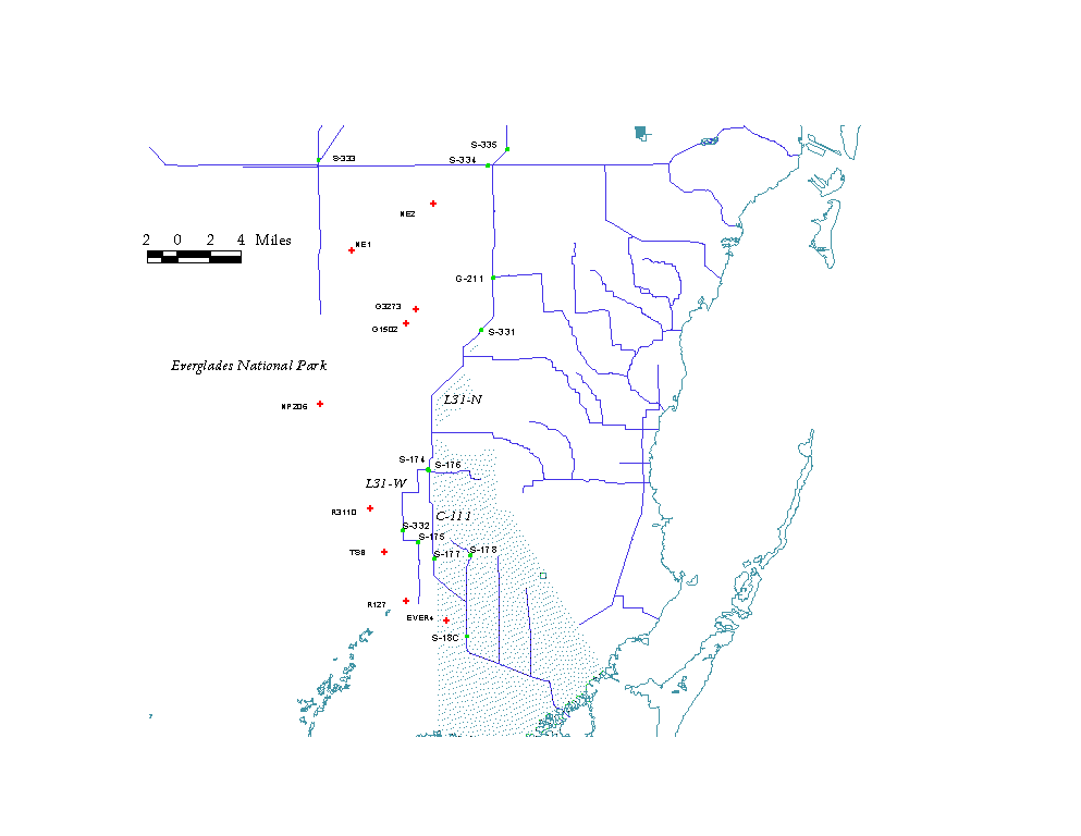
Conceptual Model Initial Phase - S332D References List of Tables List of Figures IntroductionCanals in the C-111 basin (Figure 1) are operated to provide water supply and flood protection for agricultural and urban areas and to the deliver flows to Taylor Slough and coastal basins of Everglades National Park (ENP). West-to-east hydraulic gradients between the adjacent ENP marsh and basin canals induce large horizontal groundwater flows through relatively permeable substrates. Resulting diversions of water from Northeast Shark Slough and Taylor Slough to the southern C-111 basin cause reductions in marsh hydroperiod and associated ecological impacts. These diversions may also have significant negative impacts on Florida Bay. Major alterations to the canal system are planned by the Corps of Engineers to reduce these impacts while continuing to provide water-supply and flood-protection benefits. A buffer strip will be constructed between the ENP marsh and the main drainage canals. Flows will be pumped from the drainage canals to raise water levels in the buffer, flatten regional hydraulic gradients, and thereby reduce groundwater flows. Overflows of surface water from the buffer into ENP may occur during periods of high flows. There are currently three direct outlets from basin canals into ENP (S332, S175, and S18C). Protection of water quality in these and any new surface or groundwater discharges created by the project is a high priority. Monitoring efforts by the South Florida Water Management District (SFWMD), U.S. Geological Survey (USGS) and ENP have generated substantial water-quality and hydrologic data, which date primarily back to 1983. The Florida Department of Environmental Protection (1997) has compiled and analyzed the broad spectrum of water-quality data available from the basin. This report analyzes portions of the data pertaining primarily to canal phosphorus concentrations and loads. Historical variations in phosphorus concentration at monitored points in the basin are summarized and correlated with hydrologic factors. Results are discussed in the relation to conceptual models describing sources and sinks of flow and phosphorus under historical and future conditions. The report provides a foundation for future development of quantitative models to evaluate water-quality aspects of specific buffer designs. ConclusionsWater and phosphorus balances have been developed for the C111 basin using monitoring data from 1984-1996. Inflows have been partitioned into four sources: outflows from L31N (S174+S176) and local inflows to each of three canal reaches (L31W between S174 and S332/S175, C111-North between S176 and S177, and C111-South between S177 and S18C). Outflows and retention (net losses) have also been quantified for each reach. Local inflows to the L31N, L31W, and C111-South are strongly correlated with head differentials between the adjacent ENP marsh and the respective canal segments. Seepage rate estimates per foot of head differential are 281-420 kac-ft/yr/ft for L-31N, 84-134 kac-ft/yr/ft for L31W, and 129 kac-ft/ft/yr for C111-South. These correlations reflect a direct linkage between seepage losses from ENP and canal design/operation. They generally support the buffer design concept as an effective means for controlling seepage losses. Effects of dilution by seepage from ENP are reflected in negative correlations between phosphorus concentrations measured at the outflow from L31N (S174+S176) and upstream head differential (marsh stage – canal stage) evaluated on a yearly, monthly or daily basis. Flow-weighted-mean concentrations at S176 vary systematically from ~30 ppb during periods of low head differential, when L31N inflows are dominated by deliveries through S335, to ~ 6 ppb during periods of high head differential, when L31N inflows are dominated by seepage from ENP. Total nitrogen and chloride concentrations at this location are also negatively correlated with head differential. Phosphorus loads and concentrations in the L31N and L31W canals are controlled largely by deliveries from the North (S334/S335) and seepage from ENP. Impacts of local watershed contributions are difficult to detect in the presence of large volumes of recycled seepage from ENP. Based upon the apparent lack of response in canal phosphorus concentrations to rainfall events in recent years, it is likely that most of the local watershed contributions are in the form of seepage instead of direct runoff. Compilation of additional canal and groundwater quality data would provide an improved basis for estimating phosphorus concentrations in local inflows to the L31N and L31W. Relatively low phosphorus concentrations measured at L31N and L31W structures in recent wet years reflect high ENP stages and high volumes of seepage from ENP. Over the short term, concentrations at ENP inflow points S332 and S175 may increase above current levels when normal or dry rainfall years are encountered. Over the long term, concentrations may decline as a result of phosphorus load controls being implemented at inflows to the Water Conservation Areas. The L31W canal acted as a net sink for flow and phosphorus during dry years (1989-1990). These losses partially reflect seepage out of the canal into the adjacent ENP marsh, which occurred during a period when phosphorus concentrations at inflows to the L31W canal were highest (25-30 ppb). An inventory of soils and vegetation in marsh areas adjacent to the canal would help to determine whether enrichment resulting from such seepage is a valid water-quality concern. Phosphorus loads and concentrations at S18C are influenced by contributions from the northern C111 and by drainage from local watersheds. Concentrations in local drainage show an increasing response to rainfall. Compared with outflows from L31N and local inflows to L31W and C111-North, local inflows to the C111 South reach accounted for the largest source of phosphorus to the C111 canal over the 1991-1994 period. The flow-weighted-mean phosphorus concentration in local inflows to this reach averaged 24 ppb, compared with a range of 6 – 10 ppb for the other reaches. Development of a phosphorus-control strategy for this portion of the basin is suggested. If the C111 buffer project does not create new sources of phosphorus (by promoting development, providing more aggressive flood control for existing areas, or promoting diversion of flows from other basins), it is unlikely that the full-scale project will cause net increase in phosphorus load to ENP relative to historical conditions. Reductions in phosphorus load may occur as a consequence of reduced seepage, implementation of phosphorus controls at inflows to the WCA’s, and phosphorus uptake within the buffer. Impacts of the buffer project on phosphorus concentrations in flows discharged to ENP would be more difficult to predict, particularly if estimates on a short time step are required. Reductions in the dilution historically provided by recycled seepage from ENP would tend to cause increases in basin outflow concentration. These concentration increases may be offset by the load reduction mechanisms discussed above. ENP inflow concentrations may be highest in overflows from the buffer during and following intense rainfall periods. Consistent increases in phosphorus concentrations following large storm events are not evident in historical data from S176 and S332, however. This suggests that most of the canal inflows from local watersheds following storms are in the form of seepage instead of surface runoff. Assuming that the buffer itself does not represent a significant source of phosphorus, there is no indication that dramatic spikes of flow with high phosphorus concentrations water would be discharged into or out of the buffer during overflow periods. The various phases of the buffer design should be reviewed to insure that they provide operational flexibility to the maximum feasible extent. Changes to the designs of future phases and/or operations can be made in response to monitoring results and current hydrologic and water-quality management objectives. If operation of S332D (initial project phase) does not induce additional groundwater inflow to the L31N from the East, this phase is not likely to cause a net increase in phosphorus load discharged to ENP. As a consequence reduced seepage recycling in L31W, there may be a net overall increase in inflow concentration. Provision of a flow-through treatment area in western sections of the Frog Pond may help to reduce concentrations and loads to Taylor Slough. Depending upon design and operation, such a measure may reduce hydrologic benefits, however. Further analyses of treatment requirements and options for the Frog Pond area are needed. Because of reduced dilution of local inflows to the C111-South canal, increases in phosphorus concentration (not load) may occur at S18C as a consequence of S332D operation, unless adequate load-control measures are implemented in the C11-South watershed. Various project phases will change the locations and forms (surface vs. groundwater) of basin outflows to ENP. Appropriate adjustments in current procedures for monitoring compliance of basin discharges with the Settlement Agreement should be developed by the Technical Oversight Committee. Potential revisions to the fixed 11 ppb annual limit to account for the substantial hydrologic variance components identified above (relationships between canal P concentration and head) should also be considered by the TOC. Development of a water-quality model is suggested to provide a basis for evaluating specific designs for each phase of the buffer project. The model would rely heavily upon output from independent hydrologic simulations defining the water balances of canal and buffer segments. Water-quality predictions would necessarily reflect uncertainties in the hydrologic simulations, as well as uncertainties in simulating phosphorus retention mechanisms in the buffer water column and soils. Evaluation of these uncertainties will provide a basis for identifying needs for additional monitoring and/or experimental data to provide an adequate foundation for predicting water quality impacts and developing control strategies. The following future work is proposed for refining the analysis of historical conditions and developing more quantitative predictions of future conditions:
Return to W.W.Walker Home Page
http://www.wwwalker.net/c111
|